


Scalaire toulouti

cobut.jp@gmail.com
User
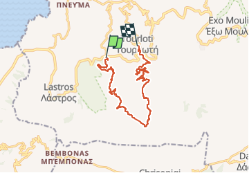

Length
16.3 km

Max alt
798 m

Uphill gradient
626 m
Km-Effort
24 km

Min alt
269 m

Downhill gradient
571 m
Boucle
No
Creation date :
2023-05-07 06:57:17.0
Updated on :
2023-05-07 14:56:52.486
6h52
Difficulty : Very difficult

FREE GPS app for hiking
 SityTrail
IGN / Geographical institutes
SityTrail Plus
The world is yours!
About
Trail Walking of 16.3 km to be discovered at Region of Crete, Lasithi Regional Unit, Municipality of Sfaka. This trail is proposed by cobut.jp@gmail.com.
Description
Tour l’ouït
Positioning
Country:
Greece
Region :
Region of Crete
Department/Province :
Lasithi Regional Unit
Municipality :
Municipality of Sfaka
Location:
Unknown
Start:(Dec)
Start:(UTM)
401947 ; 3890687 (35S) N.
Comments